 The University of Iowa department of Geographical Information Systems (GIS) is a department focused on conducting research and teaching students about social and biophysical systems and the events that shape the world. They focus on understanding these dynamics with emphasis on human-environment interactions as well as the science and technologies needed to analyze, model, and visualize geographical processes.
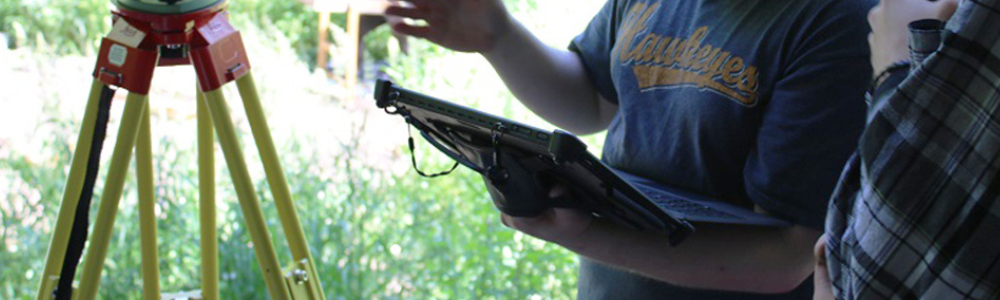
Out in the field, the GIS Department uses a Light Detection and Ranging (LiDAR) machine to collect geographical data. LiDAR instruments project a laser at a surface and measure the time it takes to return to the machine. The light moves at a constant and known speed so the LiDAR instrument can calculate the distance between itself and the target with high accuracy. The University of Iowa GIS uses this technology to collect data that then allows students to view high-resolution maps to monitor different geological landscapes across years.
Customer Challenge
When using the LiDAR machine, the data collection process includes setting up, scanning the landscape, then returning to the lab and downloading the results in hopes that the information was of satisfactory quality to produce geological maps. This limited the department’s ability to identify errors in the field and visualize the data as it was being collected.
The department began searching for a solution that would allow them to increase overall efficiency of collecting scans and would assist in educating students on how LiDAR technology worked.
MobileDemand Solution
When the Department of GIS started researching for a solution, MobileDemand came up at the top of their list. “The decision to reach out to MobileDemand was an easy one," said Adam Skibbe, GIS Administrator. “Once we found out they were a local company it was even more important to us to pursue a relationship.”
The Microsoft Surface Pro bundled solution from MobileDemand with screen protector, rugged case and type cover keyboard was the ideal solution. It provided superior features such as the back hand strap and briefcase handle for easy carrying out in different environments. This was beneficial for the Department of GIS because they carry all their equipment out to different sites. Additionally, the Surface Pro unit allowed the Department of GIS to connect, through USB connection, to the LiDAR system and collect real-time visualization of their data allowing them to identify and make corrections in their methods, rather than returning to the field later to fix the errors.
Results
As a result of using the Surface Pro bundled solution, the Department of GIS has increased the overall productivity and the ability to teach students when out mapping geographical landscapes. “The premium rugged case has allowed us to add a dimension of training and education for our students to learn how these various interfaces work,” says Skibbe.
The Department of GIS has plans to deploy more rugged Surface tablet bundles to streamline operational efficiencies and increase educational opportunities out in the field.